In order to use Sutori, you must enable Javascript in your browser. You can find instructions on how to do this here.

Aral Sea Shrinkage Timeline | Sutori

A történet kinyomtatásához kérjük, használja a történet eszköztárában található linket.

Sparks. By Jakub Skafiriak (https://unsplash.com/photos/AljDaiCbCVY)
DX

Aral Sea Shrinkage Timeline

//////

cdd

1930s - 1950s

Construction of Soviet irrigation canals begins


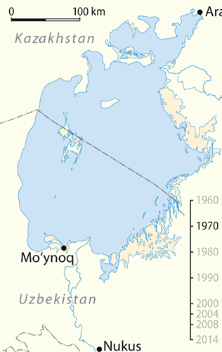
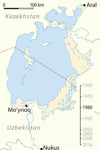
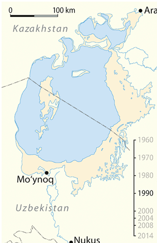
As part of the USSR's 'five-year plan' for the development of their national economy, Soviet officials employ over 6 million workers to construct large-scale canals over a period of 10 years that would irrigate water from the Soviet-controlled Syr Darya and Amu Darya to the massive fields that were to be used to grow exclusively cotton, or 'white gold' as it was known as at the time, for exportation and profit.


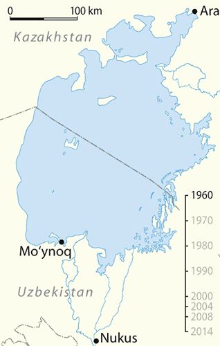
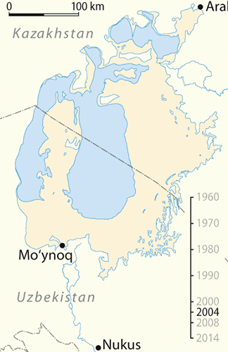
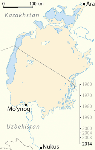
At the time, the Aral Sea was the 4th largest lake in the world, and could be described as an oasis in a desert land. Humans, animals and plants alike relied on the water that came from the sea greatly; humans in particular built entire industries around fishing and similar practices that the Aral Sea provided the opportunity for. By siphoning parts of the Amu and Syr rivers, the Soviets had cut off the Aral Sea's main source of incoming water.

Above: The Aral Sea in 1960

1960s

The start of the Aral catastrophe


Unfortunately, many of the canals that were constructed by the Soviets as a part of their prior plans were poorly engineered; in 2012, it was estimated that only 12% of canals were waterproofed, and only a quarter of Soviet-built canals were built with anti-infiltration linings. Hence, between 30 and 75% of water that passed through these canals was wasted or evaporated. The poor engineering could be attributed to the poor educations of the workers. unsafe working conditions and the underdeveloped technology of the time.


Water that hadn't been wasted went straight to the cotton farms. The immense water loss from the faulty canals, coupled with the cotton plant's status as one of the thirstiest plants in the world, meant that more water needed to be drained from the Amu and Syr rivers than what was needed, exacerbating the negative impact on the Aral Sea, which relied on these two rivers greatly in the replenishing of its water.


The 1960s were the first years in which the Aral was beginning to show noticeable signs of shrinkage.


Above: The Aral Sea in 1970

1970s

Aral shrinks further


In 1945, Joseph Stalin, the leader of the USSR during that time, predicted that the Soviet Union would be the leading industrial power by 1960. This sentiment was adopted by many of the USSR's later leaders, and it is why the many scientists and engineers working on the project did not dare to speak up about the potential disastrous consequences it would have on the ecosystem and surrounding countries; they feared that they would be incarcerated for 'negative campaigning', even though they knew of the repercussions from as early as the late 1960s and early 70s.


Thus, operations at the Syr and Amu rivers continued, and the Aral was further depleted.

Above: The Aral Sea during 1980

1987s

Aral splits in two


Due to the immense water loss the Aral was suffering and shoreline recessions from Russian terraforming in the area, the Aral Sea split into two parts - the North Aral and the South Aral. The South was substantially larger than the North, but it would eventually come to be the first to completely dry out.


Above: The Aral Sea in 1990

1990s

Experts ring the death knell for the Aral


In 1991, Uzbekistan gained independence from the Soviet Union. It was the first country to attempt any serious revitalization of the Aral.


Craig Murray, Uzbekistan's UK ambassador at the time, attributed the shrinkage of the sea to president Islam Karimov's negligence; under his cotton policy for Uzbekistan at the time, Crop rotation was not used, huge amounts of unsustainable pesticides were used and the system was generally wasteful.


The runoff from the cotton fields, which had been doused with copious amounts of harmful chemicals, flowed into the Aral sea, polluting it greatly and making subsequent endeavours in its revitalization even more difficult. Additionally, as the rate of evaporation in the sea was increasing more than the rate of replacement, the water became hypersaline, further adding to its toxicity. This toxicity eventually entered the food chain due to plants sucking the toxic water up for food, and other animals eating those plants etc. It greatly affected humans as well; in areas that relied on the Aral's water for consumption and bathing, liver, heart and eye condition rates skyrocketed, and child and childbirth mortality rates were higher than ever before.

Above: The Aral Sea during late 2003/early 2004

2003

Aral splits further


Efforts into regenerating the Aral sea became exponentially harder when the sea split further, into eastern and western basins. The shoreline was disfigured, unrecognizable by now. Because of deep-water hyper salinity, only the upper layer of the sea was getting any heat, so evaporation rates were higher than expected.

2004-2006

Hope for the North Aral


In order to conserve at least some part of the Aral Sea, a plan was announced for the construction of the Dike Kokaral: a great dam that would prevent water spillage from the North Aral to the drying South, which had shrunk by nearly 90%. Construction of the dam finished in early 2006, and it was regarded as a success by many; it remains to this day a sprawling ecosystem due to the efforts of many revitalisers.

2007 - Present

Completely dry


By 2007, the South Aral sea had completely dried up. It is now known as the Aralkum Desert. Water is occasionally deposited by the melting of glaciers, but for now the once sprawling sea is now a toxic wasteland, prone to dust storms and intense heat.